Sunday, December 28, 2008

Mt Sunday (a.k.a. Edoras)


Mount Sunday is a couple of hour's drive from Christchurch, nestled between Mt Potts and Erewhon Stations. In NZ a station is not just something found on a railway line, it is also a term referring to large high country farms or ranches and that is the context for Mt Sunday. It's name refers to days gone by when the farm hands would race their horses to the peak on their day off, Sunday. Kirwin and I found ourselves atop Mt Sunday during a 4WD tour on 15-Dec-2008.

Mt Sunday's biggest claim to fame is as the setting for Edoras in Peter Jackson's Lord of the Rings movies, specifically "The Two Towers" and "Return of the King". Kirwin was a bit miffed that it was a drizzly day when we got there and now nobody will believe us that the scenery really wasn't computer generated. Behind those clouds we promise you there are big mountains!

If you're a LotR buff, you might remember a scene in which the flag of Rohan is torn from its flagpole by a gust of wind just as Gandalf, Gimli, Legolas and Aragorn arrive at the base of Edoras? Well, Mt Sunday lies in an extremely windy valley. During one take of filming the flag tore free (unplanned) but director Peter Jackson thought the shot looked so good that he decided to keep it in the movie. Kirwin and I had a good hunt around and managed to find it. This picture is more or less taken from the same angle as in Return of the King at a point just after the fire beacons have lit and Theoden agrees to come to the aid of Gondor. He walks out in front of the great hall and looks down the valley as the Rohirrim muster. He tells Gamling to make haste across the Riddermark.

Another interesting fact about the filming of Lord of the Rings is that the Tolkein family requested that none of the sets were left in tact upon completion. This was out of respect for J.R.R. Tolkein's imagination which held that Middle Earth was located in Europe. The set for Edoras took 8 months to build, and it was only used for about a week's worth of filming before being dismantled. Prior to construction, the position of every plant on Mt Sunday was noted using GPS. They were then temporarily replanted in a purpose-built nursery. After the set was dismantled all the plants were returned to their original position. Today there are very few signs that Edoras ever existed there. Now, that's commitment to the environment!

Here's a different shot of Mt Sunday, with a storm rolling in over the mountains to the north. In this photo it looks like a small hillock on the flat, just below and to the right of the clouded valley. You can click on the pic to see a larger version. At least now you can see the mountains surrounding it are real. As I write this Kirwin is making some smart remarks about summertime weather in NZ.

Saturday, December 27, 2008

Christchurch

Further down the eastern coast from Kaikoura is Christchurch, the largest city in the South Island. Although inhabited by moa hunters as much as 1,000 years ago, it's current look and feel was planned by two British gentlemen (Godley and Wakefield) in 1847 and was named after the Oxford college Godley had attended. Christchurch was NZ's first city and now has approximately 350,000 inhabitants.

The most well-known landmark in Christchurch is Christ Church Cathedral (an Anglican diocese) located in The Square at the very heart of the city. Construction commenced in 1864 but owing to financial hurdles it was not completed until 1904. After attending a morning service in June 1901, the Duke of Cornwall and his wife (King George V and Queen Mary) started a trend of climbing the tower to admire the view.

Next to the cathedral is 18 meter high steel and aluminium artwork known simply as Chalice, commissioned by Turning Point 2000 Trust to celebrate the city's 150th birthday as well as the new millennium. The leaves depicted are mapou, kowhai, mahoe, totara, karamu, titoki, ngaio, maratata and koromiko - native trees that grew in the area prior to British colonisation.

Kaikoura

The plan, in a nutshell is to drive down the east coast of the South Island as far as Christchurch, and then head inland down to Queenstown before working our way back to Picton via the West Coast (another of those uncreative location names inherited from Captain Cook).

Our first stop is at a place called Kaikoura. It is a Maori name that roughly translates into English as feast of crayfish, a testiment to the fabulous crayfish found in the waters surrounding the township. The rich sealife in the area also includes large a colony of dolphins and seals. Kaikoura is beloved by Kiwi scuba divers and in the last 20 years a thriving whale watching industry has developed.

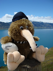
It was a bit of a grey day, but Kirwin thought he'd take five on this funky public bench facing out to sea. In the background are the Kaikoura ranges, shrouded in low hanging cloud. We drove past them to get here.

On 13-Dec-2008 Kirwin makes his first visit to Kaikoura. He wasn't feeling too well so we decided not to go and watch the whales this time around.

Cook Strait

When Captain Cook discovered New Zealand for the English - the Maori people had already discovered it for themselves - he wasn't overly creative about naming the two main islands. Most people think Kiwis refer to the northern and southern islands by their relative location. But no, they really are named simply as North Island and South Island.

Wellington is the capital of New Zealand. It is located at the southern tip of the North Island and is known by the locals as Windy Wellington. You could think of it as the Chicago of the South Pacific. Predominant westerlies come barrelling across the Tasman Sea from Australia and are forcibly funneled into Cook Strait, the piece of water separating the North and South Islands. Wellington is also where Kirwin and I call home.

A network of ferries connects the two islands, mostly between Wellington and Picton. The locals refer to such ferries as the Picton Ferry. The best known fleet of ships are branded as the Interislander. This photo was taken in the belly of their ship the Kaitaki as vehicle drivers prepare to drive ashore.


The trip takes about three and a half hours and is quite scenic, especially through the Marlborough Sounds near Picton. Sometimes, because of the wind, the Cook Strait can be very rough and sailings may have to be canceled.

On 13-Dec-2008, Kirwin made his first journey across the Cook Strait to begin his adventure around the South Island.